The most significant results obtained by IGM-CNR since 1971 through seismic reflection profiling (sparker 30 kJ, monotrace) and dredgings in the Northern Ionian Sea are presented. A large part of the margins of the Ionian Sea were explored (7,000 n m), but the reconstruction inferred from the seismic reflection profiles is limited by the fact that the great geodynamic problems concerning also the all Eastern Mediterranean Sea as a whole are still unsolved. Finally, the areas of gravitative decollments are present on a map where there are also the bigger geological instabilities.
INTRODUCTION
Since 1971, the Institute of Marine Geology of National Council of Researches of Bologna (Italy) has had joint programs with other institutions to understand the marine geology of the Northern Ionian Sea, with an emphasis on understanding the morphology, major structures and geodynamics. This paper presents an overview of geomorphological regions including both previously published work and new data.
The stability of characteristic physiographic provinces is illustrated and is primarly dependent on sedimentation, structure and seismicity.
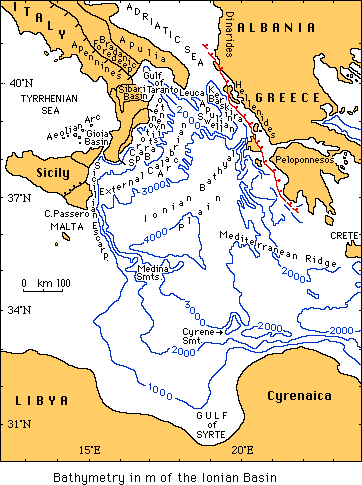
The northern Ionian Sea is a part of the Mediterranean Basin, covering a triangular area with cape S. Maria di Leuca, cape Passero and the Crete Island at the apices. In most of this region, the continental shelf is narrow or absent. The continental slope is usually steep, reaching a bathyal plain offshore at a depth of 3500-4000 m.
Each physiographic-structural province has a distinct morphology and geology, but all have a common geodynamic setting.
The principal characteristics of each province will be described, starting in the North and continuing counterclockwise.
Additional details for each area may be found in work cited in bibliography.
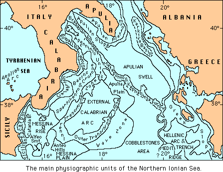
PHYSIOGRAPHY and STRUCTURAL UNITS
The Kerkira Basin is an elongated NW-SE oriented basin that receives mostly terrigenous sediments from the Adriatic Basin and from Greece. No drills was done but seismic reflection profiles allows identification of the Messinian evaporites. The basin is filled by a sub-horizontally stratified mud of Plio-Quaternary age. The sedimentary fill is about 1500 m thick.
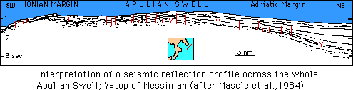
The Apulian Swell is a submarine extension of the Salentina peninsula (Apulia land), and terminates to the SE against the Greek slopes. It is bordered to the east by the Hellenides. This feature is broadly arched, with the NE limb dipping gently toward the Kerkira Basin, and the SW limb dipping more steeply toward the bathyal plain and showing evidence for slope instability. the substrata of the Apulian swell are Upper Cretaceous limestones and dolomites, overlain by a thin layer of evaporites. Above this, dredging shows Plio-Pleistocene deposits, starting in the lower Pliocene age. The area is crossed by numerous NW-SE oriented normal faults. This region is a foreland area for both the Apennines to the west and hellenides to the east and is geodynamically stable.
North-West of the Apulian Swell is the Apulian Slope which is in part contained in the Gulf of Taranto. This Apulia slope is continuous with the Apulian Swell, but it is not as steep. It contains Upper Cretaceous limestones, which dips westward under the Apennine tectonic units.
The Plio-Pleistocene sequence overlies the Cretaceous units, sometimes Messinian layers. The normal faults trend as in Apulian Swell. Much evidence of submarine landslides is present.
The Gulf of Taranto is formed by the southern Apulian Slope, the Great Valley of Taranto, and by a gentle slope on the west that include small basins, valleys and low hills. The western slope is the submarine continuation of the Apennine Chain. The surface morphology of the Gulf reflects the underlying strata. The western slope is the submarine extension of allochtonous Apennine units with chaotic texture susceptible to large-scale slumping.
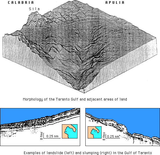
Many faults are present, most frequently oriented NNW-SSE and NE-SW. The western margin of the Taranto Valley is the front of the allochthonous Apennine. The Taranto Valley extends through the center of the Gulf and contains sub-horizontal Plio-Pleistocene sediments.The Valley represents the submarine extension of the Bradanic Foredeep and reaches to the Ionian Bathyal Plain.
The Metaponto-Kephallinia Furrow is a relatively (sometimes more than 1000 m) deep through that is partly covered by sub-horizontal Plio-Quaternary sediments. There are numerous discontinuous elongated basins, NW-SE, that have sediment thickness decreasing to the SE.
 The Calabria Slope has numerous canyons and gullies with gravity slides at the lower ends, caused by tectonic movements or earthquakes. One seismic line (south of Crotone), calibrated with samples from dredging, shows the intersection of a complete sequence (Messinian?) in between Plio-Quaternary succession. The acoustic basement is probably represented by granitoids and metamorphics of Calabria.
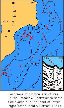
The Crotone-Spartivento Basin is a great pre-Messinian (Tortonian?) structural depression, bounded to the west by land. it is covered by continuous Plio-Pleistocene deposits. The basin has an axis parallel to the coast (NNE-SSW) with numerous normal faults parallel to the axis.
Many (salt?) diapirs of Messinian evaporites rise to the surface, covered by a veneer at recent sediments.
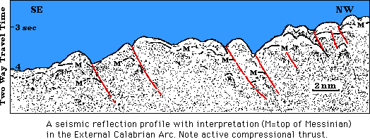
The External Calabrian Arc has an irregular topography and complex structure. It is nearly parallel to the Calabro-Peloritano Arc in Calabria. It has three components: the CrotoneSpartivento slope; the Calabrian ridge and an intermediate depression. numerous compressional faults are present. (Rossi and Sartori (1981).
The Calabria Slope has numerous canyons and gullies with gravity slides at the lower ends, caused by tectonic movements or earthquakes. One seismic line (south of Crotone), calibrated with samples from dredging, shows the intersection of a complete sequence (Messinian?) in between Plio-Quaternary succession. The acoustic basement is probably represented by granitoids and metamorphics of Calabria.
The Crotone-Spartivento Basin is a great pre-Messinian (Tortonian?) structural depression, bounded to the west by land. it is covered by continuous Plio-Pleistocene deposits. The basin has an axis parallel to the coast (NNE-SSW) with numerous normal faults parallel to the axis.
Many (salt?) diapirs of Messinian evaporites rise to the surface, covered by a veneer at recent sediments.
The External Calabrian Arc has an irregular topography and complex structure. It is nearly parallel to the Calabro-Peloritano Arc in Calabria. It has three components: the CrotoneSpartivento slope; the Calabrian ridge and an intermediate depression. numerous compressional faults are present. (Rossi and Sartori (1981).
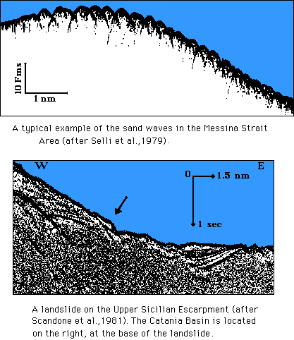
The Messina Strait connects the Ionian and the Tyrrhenian Seas. Its mean depth is 200-300 m, but at its midpoint, a sill is only 110 m deep. In the Strait several types of sea bottom are present: a rough bottom is covered with sandstones and paraconglomerates; a smooth bottom with parallel sub-bottom reflectors formed by silty-clay and fine sand contacts; a smooth bottom with no visible sub-bottom reflectors and poor seismic penetration is characterized by the presence of rocks, cobbles, or coarse sand. the current velocity may reach 5 knots near the bottom, and it controls the sediment distribution, negating deposition of fine-grained material. structurally, the Strait is a graben, formed during the Pleistocene.
On the Ionian side, the Messina strait extends into the Canyon of Messina that lies along a major N-S fault. This canyon has many tributaries from both the Sicily and Calabria sides.
South of the Messina Strait is the Messina Rise which slopes gently to the south. In this area, many small basins of Messinian age are present. the largest of these is the Catania Basin, witch has a N-S axis and contains sub-horizontal Plio-Pleistocene sediments. Turbidites, triggered by seismic activity, are common throughout the Rise. At the base of Messina Canyon, no fan is present, although numerous publications have inferred its existence. From a geodynamic point of view, the Messina Rise is probably the result of a rotation of Sicily away from Calabria due to the opening of the Tyrrhenian Sea.
The Alfeo Seamount and the Anteo Hills is the only one found on the western Ionian margin. They are located South of the Messina Rise, at the boundary between the Sicilian Escarpment and the Ionian Bathyal Plain. They consist of Jurassic limestone (Dogger), covered by Plio-Pleistocene sediments. They are a horsts or the hills related from the Ragusa region of Eastern Sicily.
The Sicilian Escarpment divides the Island of Sicily from the Ionian Sea. It trends N-S, extending 160 nautical miles, and slopes eastward at about 15º. Dredging and exploration by the French submersible Cyana show that oldest rocks exposed are Triassic limestones and dolomites. Many indications of slope instability and large scale mass movement are present.
The Ionian Bathyal Plain, formed by Messina and Apulia Plains, is generally smooth, where the Plio-Pleistocene sediments are sub-horizontal. The Bathyal Plain also includes a cobblestones area which has undulations with wavelengths of a few kilometers and amplitude of 20-100 m.
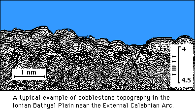
Their orientation are variable, and sometimes small basins with sub-horizontal sediments are present and aligned with the adjacent undulations. the origin of the cobblestone topography has been debated extensively, and possible mechanism suggested for their origin include tectonic, olisthostromes, megaripples or karst phenomena.
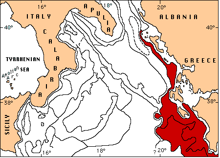
The Western Margin of Greece and the terminal part of the Hellenic Arc have a narrow continental shelf and include a large trough that is parallel to the coast. Numerous seamount and deep trenches are present in the trough.
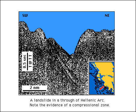
One of these trenches, the North Matapan, is the deepest place in the entire Mediterranean Sea (-5016 m). The thickness of Plio-Quaternary sediments in this trough is variable as some locations lack sediments, while others are completely covered. The entire region shows evidence of compression, probably due to subduction of the African Plate beneath the European Plate.
The intensity of this movement along this margin has caused tectonic landslides and formed breccias, whereas turbidites are common everywhere. The northern boundary of the Hellenic Arc is formed by a strike-slip fault that divides the Adriatic domain and the Aegean domain.
DISCUSSION
The northern Ionian Sea is an area of great instability which depends on structural characteristics and the dynamics of recent sediments. The rate of sediment accumulation in its various provinces depends on the sediment source and sea floor morphology. These factors may amplify or cancel, causing variability in the morphology of the sea floor.
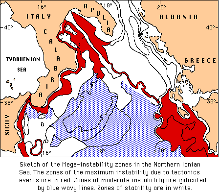
The zone of greatest instability is represented by Calabria - Sicilian, Southern Apulian, and Greek slopes, and by the cobblestones areas in the Ionian Bathial Plain. Landslides are very frequentb on the slopes and less frequent in the External calabrian Arc and in the cobblestones areas.
In effect, the External Calabrian Arc and the Hellenic Arc not in contact yet, but they are approaching each other as indicated by cobblestones topography. the latter may derive from tectonic activity, although not severe.
On the contrary, the calabrian margin evolution is ruled by stresses generated by tyrrhenian rifting and by the compressional activity of the External Calabrian Arc. This are is no longer active in the Taranto Gulf since Upper Pliocene times.
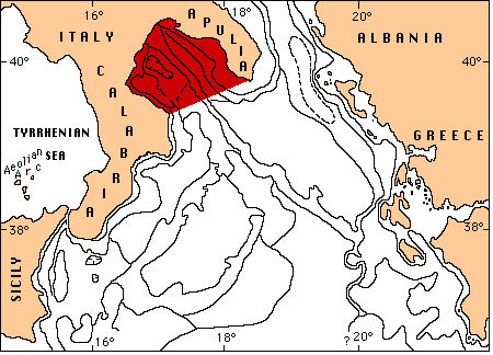
The Apulian Swell represents a stable area (part of the African Plate or Adria Plate), inserted between the Apenninic and Hellenic domains, towards which thrust units of both mountain chains have been transported.
This is the reason for which along the whole Calabrian and Hellenic margins, landslide and instability zones occur. They produce gravitative decollements and mass wasting phenomena.
As regards the calabrian margin, the NW-SE tilting of the calabro-thyrrhenian domain may have enhanced such landslides.
The instability of the Ionian margin appears closely linked to the complex, active tectonic setting.
Moreover we should take into account also the basic importance of earthquakes, occurring in the Messina Strait zone and its neighborhoods and the along the Hellenic margin. They have produced remarkably important geologic instabilities.

THE BIBLIOGRAPHY

Home

First opening site: January, 1997
